Banff to Jasper: Icefields Parkway Road Trip
Driving the Icefields Parkway: the stops that matter, Lake Louise and Moraine access, wildlife, seasons and winter conditions.
In this guide
- Quick Facts
- Essential Planning: Passes, Access, and Logistics
- The First Leg: Lake Louise to Bow Summit
- The Wolf and the Canyon: Peyto Lake and Mistaya
- The Crossing and the Climb
- At the Toe of the Glacier: Columbia Icefield
- Top Hikes Along the Parkway
- Waterfalls and Wilderness: The Final Stretch to Jasper
- Wildlife on the Parkway: Respect and Safety
- When to Drive: A Season for Everything
- Jasper: The End of the Road
- Explore in Depth
- Frequently Asked Questions
- Final Thoughts
This guide is part of our Top Things to Do in Canada: Destinations Coast to Coast — start there for the overview, when to go and how to get around.
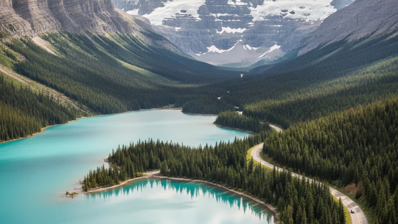
Crest Bow Summit and Peyto Lake appears below, sprawled out like a splash of impossible turquoise paint, the shape of a wolf’s head perfectly outlined in the valley. It’s the kind of view that makes you put the camera down after one shot just to soak it in. That single viewpoint encapsulates the entire Icefields Parkway experience: every turn reveals a vista so grand, so intensely colourful and wild, that it feels less like a road trip and more like a pilgrimage through the heart of the planet’s raw power.
This isn’t just a drive; it's a destination in itself. Stretching 232 kilometres between Lake Louise and Jasper, this ribbon of asphalt cuts through one of the most spectacular mountain landscapes on Earth. While you could technically drive it in about three hours, to do so would be to miss the point entirely. This guide is built to help you turn a three-hour transit into a full, unforgettable day (or more) of adventure. We'll cover the essential stops, hikes for all abilities, the critical logistics of fuel and food, wildlife safety, and practical tips for photography and avoiding the worst of the crowds. So, fill your tank, pack your lunch, and let’s hit the road.
Quick Facts
- Location: Highway 93 North, connecting Lake Louise in Banff National Park with Jasper in Jasper National Park, Alberta, Canada.
- Getting There: The southern end starts near Lake Louise, about a 45-minute drive from the town of Banff. The northern end is in Jasper. Most travellers fly into Calgary International Airport (YYC) and drive to Banff to begin.
- Getting Around: A personal vehicle is essential. There are some tour buses, but self-driving gives you the freedom to explore at your own pace. All-wheel drive or 4x4 vehicles are recommended, and winter tyres are mandatory for winter travel.
- Language & Currency: English is the primary language. The currency is the Canadian Dollar, but credit cards are widely accepted at the few commercial stops.
- Best Time to Visit: June to September offers the best weather and access to all trails and services. Mid-to-late September provides stunning autumn colours with fewer crowds. Winter (December-March) is for the truly adventurous, with road closures possible.
Essential Planning: Passes, Access, and Logistics
Before you even turn the key, a bit of planning is crucial. The Icefields Parkway runs entirely within two national parks, Banff and Jasper. This means you will need a Parks Canada Discovery Pass for your vehicle. You can buy this online in advance, at the park gates upon entry, or at visitor centres in Banff and Jasper. It’s usually valid for a set period, covering all national parks in Canada. Always check the official Parks Canada website for the current pass types and requirements.
One of the biggest changes in recent years affects the very start of your journey. Access to the iconic Moraine Lake is now highly restricted. Private vehicles are no longer permitted to drive up to Moraine Lake at any time of day. You must book a spot on a Parks Canada shuttle, a commercial bus, or a private tour operator to visit. These spots are released in batches and sell out extremely fast. The same applies to managing crowds at Lake Louise, where parking is incredibly limited and finding a spot after sunrise is nearly impossible. Using the shuttle system is now the most reliable way to see both famous lakes. You absolutely must check the Parks Canada website for the latest shuttle schedules, booking windows, and reservation details well in advance of your trip.
Finally, a couple of life-saving logistical points. There is no mobile phone signal for almost the entire length of the parkway. Download offline maps, tell someone your travel plan, and be prepared to be disconnected. Secondly, fill up your fuel tank in Lake Louise or Banff before you set off. The only fuel station along the entire 232-kilometre route is at the Saskatchewan River Crossing, and you can bet it will be more expensive. It's often closed in winter, so in the colder months, there is no fuel between Lake Louise and Jasper at all.
The First Leg: Lake Louise to Bow Summit
Once you’re past the turn-off from the Trans-Canada Highway, the parkway immediately begins to deliver. Your first easy stop is Herbert Lake, just a few kilometres in. On a calm morning, the mirror-like reflections of the surrounding peaks are absolutely perfect. It’s a great, quick photo op without the crowds you just left behind.
Continuing north, you’ll pass Hector Lake, another massive body of water visible from a pullout. But the first truly mandatory stop is Bow Lake. The sheer scale of the scene here is breathtaking, with the Crowfoot Glacier hanging dramatically over the northern shore and the historic, red-roofed Num-Ti-Jah Lodge sitting picture-perfect by the water. The parking area here is large, and it’s a fantastic spot to get out, stretch your legs, and walk down to the stony shore. The wind coming off the glacier-fed water has a real bite to it, even in summer, a reminder of where you are.
The Wolf and the Canyon: Peyto Lake and Mistaya
Just past Bow Lake, the parkway begins to climb towards Bow Summit, the highest point on the drive. This is where you’ll find the viewpoint for the aforementioned Peyto Lake. A short, paved walk from the upper car park leads you to the viewing platform. My best photography tip here is to arrive as early in the morning as possible. The light comes from the east, illuminating the valley and making that incredible turquoise colour—a result of glacial rock flour suspended in the water—absolutely pop. You an also walk a little further past the main platform to find less-crowded vantage points for a clearer shot.
Further down the road lies a stop many people miss: Mistaya Canyon. It requires a short, roughly 10-minute walk downhill from the car park through a lovely forest. Your reward is a powerful, swirling limestone canyon carved by the Mistaya River. You can feel the spray on your face as the water thunders through the narrow gorge. It's a fantastic contrast to the wide-open vistas, a look at the intimate, powerful geology of the Rockies. Watch your footing on the smooth, wet rocks near the edge.
The Crossing and the Climb
About 80 kilometres into your journey, you’ll reach the Saskatchewan River Crossing. This isn’t so much a scenic stop as a practical one. It's a commercial hub with a hotel, restaurant, gift shop, and that all-important fuel station. It’s a good place for a toilet break and to grab a coffee, but it's better to pack your own lunch to eat at a more scenic picnic spot. The Crossing is also where Highway 11, the David Thompson Highway, heads east, offering an alternative route and access to the beautiful Abraham Lake (famous for its frozen methane bubbles in winter).
Shortly after the Crossing, the road takes a dramatic turn. You’ll encounter the “Big Bend,” a massive hairpin turn that sends you climbing steeply up the side of a mountain, offering staggering views back down the valley you just drove through. This leads into the “Big Hill,” a long, steady ascent that brings you into the high alpine. Be sure your vehicle is in good shape for this climb.
At the Toe of the Glacier: Columbia Icefield
This is the heart of the parkway. The Columbia Icefield is the largest icefield in the Rocky Mountains, and the highway takes you right to the toe of one of its most famous glaciers: the Athabasca. The scale here is hard to comprehend. The white expanse seems to go on forever, and the Columbia Icefield Discovery Centre across the road feels dwarfed by the landscape.
From the car park, you can walk up a steep path to the glacier’s current toe. Markers along the way show just how dramatically the glacier has receded over the past century, a sobering lesson in climate change. A word of extreme caution: never, ever walk onto the glacier on your own. It might look like a solid field of ice, but it's riddled with hidden crevasses, deep cracks that can be hundreds of feet deep and covered by a thin bridge of snow. People have died falling into them. If you want to walk on the glacier, you must book a tour with a certified guide who knows the safe routes and will provide you with crampons and other safety gear.
Across the highway, you'll find tour operators offering experiences like the Ice Explorer vehicle tours onto the glacier itself and the Glacier Skywalk, a glass-floored platform extending out over the Sunwapta Valley. These are popular attractions but require booking and can be busy.
Top Hikes Along the Parkway
For those keen to stretch their legs for more than a viewpoint stroll, the Icefields Parkway is a hiker's paradise. Two trails offer maximum reward for moderate effort.
Parker Ridge Trail
Located just south of the Columbia Icefield, this is a spectacular hike. It's a series of switchbacks climbing steadily for about 2.5 kilometres, taking you high above the treeline. The effort is paid back a hundred times over when you reach the ridge and are greeted with a jaw-dropping, panoramic view of the massive Saskatchewan Glacier pouring down the valley. It’s one of the best views-for-effort hikes in the entire Rockies.
Wilcox Pass Trail
Starting from Wilcox Creek Campground about 3 kilometres south of the Icefield Centre, this trail offers a different perspective. It climbs up into a wide alpine meadow famous for its resident bighorn sheep. Once you clear the trees, you get incredible views looking back across the valley at the Athabasca, Dome, and Stutfield Glaciers. The red Parks Canada chairs partway up the trail are a perfect spot to sit and contemplate the immense ice age landscape before you.
Waterfalls and Wilderness: The Final Stretch to Jasper
As you descend from the high alpine country of the icefield, the landscape softens slightly, becoming more forested, but the drama continues. Keep an eye out for Tangle Creek Falls on your left. It’s a delicate, multi-tiered waterfall that cascades right beside the road, making it one of the easiest to access.
Further north, you absolutely must stop at Sunwapta Falls. A short walk from the car park brings you to a viewpoint overlooking a powerful torrent of water being forced through a narrow chasm. The roar is immense. For a quieter experience, take the trail that continues downstream, away from the main crowds.
The final major stop before Jasper is Athabasca Falls. While not particularly high, it is one of the most powerful and voluminous waterfalls in the Rockies. Over centuries, the river has carved an incredible canyon and a series of potholes into the rock. There are well-maintained boardwalks and bridges that let you explore the area and feel the thunderous spray. Parking here fills up very quickly, so patience is key.
Just before you reach the town of Jasper, the Valley of the Five Lakes trail offers a gorgeous, relatively easy hike around a series of small lakes, each a different shade of jade and blue. It's a wonderful, peaceful way to end your parkway journey.
Wildlife on the Parkway: Respect and Safety
The Icefields Parkway is a wildlife corridor. It’s not a zoo, it’s their home, and we are the visitors. You have a very good chance of seeing black bears, grizzly bears, elk, bighorn sheep, mountain goats, and deer. Bighorn sheep are often seen at the Goats and Glaciers viewpoint or licking salt off the road at the Big Bend. Bears are most commonly seen foraging for berries by the roadside in summer.
If you see wildlife, especially a bear, stay in your vehicle. Pull over safely if you can, but do not get out. A 'bear jam' of stopped cars is common; be patient and respectful. A telephoto lens lets you get incredible wildlife shots from a safe and respectful distance. Do not feed any animals—it's illegal and can lead to them being destroyed.
If you are hiking, you must be 'bear aware'. Hike in groups, make noise (talk, sing, clap), and carry bear spray and know how to use it. Store all food, garbage, and scented items in your vehicle or designated bear-proof lockers. A safe encounter is a distant one.
When to Drive: A Season for Everything
The character of the parkway changes dramatically with the seasons.
- Summer (June-August): This is peak season. The weather is warmest, the days are long, and all services and trails are open. It’s also the most crowded time. Start your day very early (think 6 am) to get a head start and find parking at popular spots like Peyto Lake and Athabasca Falls.
- Autumn (September-October): A standout time to visit. The crowds thin out, a crispness returns to the air, and the larch trees in the high alpine turn a brilliant gold, usually around the third week of September. This "golden larch" season is magical for hiking Parker Ridge. Services start to close down by early October.
- Winter (November-April): This is for experienced winter drivers only. The parkway is often snow-covered and icy, and road closures can happen with no notice due to avalanches or heavy snowfall. Snow tyres or mud and snow (M+S) tyres are legally required. Services are non-existent, and there is no mobile reception. However, the reward is a landscape of profound silence and beauty, blanketed in snow. It's also the best time to visit nearby Abraham Lake to see the famous frozen bubbles.
Always check road conditions on the official Alberta 511 and Parks Canada websites before you travel, especially outside of the core summer months.
Jasper: The End of the Road
Arriving in Jasper feels different from Banff. It’s a quieter, more laid-back town, a true railway town that has retained a bit of its rugged edge. It’s also the centre of the Jasper Dark Sky Preserve, one of the largest and most accessible in the world. On a clear night, the stargazing is simply out of this world.
A note for travellers: in 2024, Jasper National Park experienced a significant wildfire. While the town and the main parkway route remain accessible, some backcountry areas, trails, and facilities may have been affected or could be subject to closures. It is more important than ever to check the Parks Canada website for the most current updates, alerts, and advisories on conditions within Jasper National Park before you visit.
Explore in Depth
The Icefields Parkway is just one incredible piece of the Canadian Rockies puzzle. For more detailed planning on the gateway towns and specific activities, check out these other guides:
Frequently Asked Questions
Can I really drive the Icefields Parkway in one day?
Yes, but it will be a very full day. To do it justice, you need to start from Lake Louise no later than 8 am, and even earlier in peak summer. With stops for photos, short walks to viewpoints like Peyto Lake and Athabasca Falls, and a lunch break, you can easily expect the journey to Jasper to take 8-10 hours. It's a trip to be savoured, not rushed. Trying to drive there and back in a single day from Banff is not recommended as you'll be exhausted and won't have time to properly see anything.
Do I actually need to carry bear spray?
If you plan on doing any hiking at all, even a short walk like the one into Mistaya Canyon, the answer is an emphatic yes. It's an essential piece of safety equipment, like a seatbelt. The chances of using it are low, but if you need it, you really need it. More importantly, know how to use it—watch videos online and read the instructions before you hit the trail. For simple roadside pull-offs where you stay near your car, it's less critical, but it's always better to have it and not need it than the other way around.
Is it worth driving the Icefields Parkway in both directions?
Absolutely. The views are completely different depending on your direction of travel. Peaks that were hidden behind you on the way north become the main event on your drive south. The light also changes throughout the day, so a glacier that was in shadow in the morning might be brilliantly lit in the afternoon. If your itinerary allows for a return trip, you will not be disappointed. It gives you a second chance to visit spots you may have missed or that were too crowded on the first pass.
How difficult is it to visit Moraine Lake now?
It requires advance planning and is no longer a spontaneous side trip. Since Parks Canada restricted private vehicle access, your only options are the Parks Canada shuttle, Roam Public Transit, or a licensed tour operator. Shuttle reservations open in batches and sell out within minutes for popular dates. You must go to the Parks Canada website, find out the exact reservation release date for your travel window, and be online the moment they become available. It's competitive, but it's the only way to guarantee a visit to this truly spectacular lake.
What is the plan if my car breaks down on the parkway?
This is a serious consideration given the lack of mobile service. First, ensure your vehicle is in excellent condition and has a full tank of fuel before you start. If you do break down, pull over as safely as you can, put your hazard lights on, and stay with your vehicle. The parkway is well-travelled from May to October, so another driver will eventually come by who can drive to the next point of service (like the Icefield Centre or Jasper) to call for help for you. For extra peace of mind, especially in shoulder seasons or winter, consider renting a satellite communication device.
Final Thoughts
From the biting wind off the Athabasca Glacier to the impossible blue of Peyto Lake, the Icefields Parkway is a drive that demands your full attention, a journey that reminds you of the sheer, humbling scale of the natural world. It’s more than just one of the world’s most beautiful drives; it’s a direct encounter with the forces that shaped a continent.
My advice is simple: take your time. Put the phone away (it won’t work anyway). Stop at the unnamed pullouts. Walk the short trails. Let the grandeur of it all wash over you. This isn’t a route to be conquered, but a landscape to be experienced. And it will stay with you long after you’ve arrived in Jasper.
More Canada guides
Top Things to Do in Canada: Destinations Coast to Coast
Western Canada's mountains and coast, eastern cities and the Maritime provinces, plus getting around, travel costs and mistakes first-time…
Stand-Up Paddleboarding in Banff: Best Lakes and Rivers
Twelve paddle boarding spots across Banff National Park's lakes, with rental options, water temperatures, permit rules and the calmest…
Visiting Banff on a Budget: Practical Tips
Eight ways to visit Banff without overspending - cheaper beds, park passes, free hikes, shuttle tricks, and where the food costs bite…